SLR station Helwan
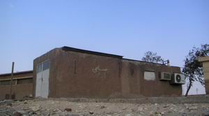
Fig. 1: SLR station Helwan, transmit and receive telescope in left part with roll-back roof, in the right part a control and laser room.
Satellite laser ranging station close Helwan, a suburb of Egyptian capital city Cairo, is the cooperative lab of the astronomical department of National Research Institute of Astronomy and Geophysics (NRIAG), Egypt and the department of physical electronics of Czech Technical University, FNSPE, Czech Republic. The aim of station, alike as many other similar stations around Earth, is the accurate and precise measurement of distance between station reference point and some artificial satellites. The measurement is based on an optical radar principle. The station location is determined by both attractive location from point of view geosciences and local climatic conditions. Especially the atmosphere transparency is strongly affected by growing local industry during last three decades of station operation. However, the station producing valuable data hitherto and thanks to a new technology and more competent local staff data quality is improving. The station operation is focused on low-orbit satellites now and its scientifically strategic location on Africa continent (until year 2000, except summer 1993, it was the only) is steadily utilizing.
Station genesis
The station was established in 1974 into Interkosmos framework. The first generation station (object 2 in fig. 2) was a mobile container (Oslavan, Czechoslovakia, operational till now) with our ruby laser, astronomical mount, control electronics and commercial computer HP 9830A, HP Cesium clock 5360, photomultiplier RCA 8852. The satellite tracking was visual only. In 1978 the time base was upgraded to LORAN C and telex communication channel was established, both thanks to Smithsonian Astrophysical Observatory (USA) grant funding. This mobile station was operational till end of 1980.
In February 1982 the second generation SLR station has been completed and activated into new building (fig. 1 and object 1 in fig. 2). It was consisting from our proper mount construction, Nd:YAG laser, control electronics and commercial control computer HP 2100S with our proper software. It was the first full blind tracking SLR station in the world. In 1987 was laser system changed again to mode-locked Nd:YAG with coude beam delivery system. In 1989 was control electronics was completely upgraded and SLR station Helwan was the first fully personal-computer-controlled in the world. Since 1990 the time subsystem is based on GPS system. And since 1991 the communication and data transfer is provided by EARN/Bitnet computer network, later on Internet. Since 1992 is SLR station Helwan a part of Eurolas network (since 1998 ILRS, network id 7831). Since 1997 is operated also by local operators. And since 2004 a stable cable internet connection in station building is established.
Current configuration of station is based on own Nd:YAG laser (20 ps FWHM, 80 mJ at 532 nm) delivered by coude to own Keplerian mount with two telescopes, Hamamatsu 6533 PMT, time counter Stanford 620, own control electronics, time base HP 58503B, meteo Paroscientific Digiquartz Met3, and own PC-based control and data processing software (CPF & polynomial fit).
Currently (2020) our participation and as a consequence the utilization of existing both tangible and intangible investments is realized by remote know-how support of local staff only, according security situation in region. The recent direct support was done exclusively by a support of the Czech Science Foundation by the grant GA205/05/0110 managed by Antonín Novotný.
Station scientific contribution from Dr. Michael R. Pearlman’s report:
Measurements from the Helwan Station help strengthen the reference frame for defining tectonic motion and enhancing the basic models which are used to define crustal deformation at the boundaries of the African plate with European and Arabian plates. This helps in monitoring of deformation at the boundaries of the Adriatic, Aegean, Anatolian and Red Sea regions, and we hope with the development of earthquake hazard assessment risk models in Southern European and North African countries. Measurement of internal deformation of the African plate will also be facilitated in combination with observations from the satellite laser ranging stations at South Africa with other geodetic techniques such as GPS in the region. This deformation would help identify areas of potential earthquake hazard within the African continent.
Data from Helwan station helps to improve the resolution of polar motion and to aid in the separation of the forces that drive the polar motion. These include the processes deep in the Earth’s core, as well as climate variations and large earthquakes. Accurate measurements of the Earth’s rotation rate help identify the influences of atmospheric variations on the rotations, which we now know are affected by El Nino events.
Global climate features also affect the motion of the geocenter, as it is driven by variations in atmospheric pressure, as well as the forces generated by ocean circulation and global surface water redistribution, including the melting of the ice-caps. The inclusion of data from Helwan station improves our ability to identify the relative contributions from the atmosphere, the oceans, and ground water storage to the behavior of the whole Earth.
Laser ranging data on radar altimeter satellites from the Helwan station also supports the direct observation of ocean circulation and sea level variations. Altimeter measurements of the topography of the ocean surface depend upon precise knowledge of satellite height relative to the center-of-mass of the Earth. The Helwan station directly supports the measurements in the Mediterranean and southern Indian Ocean, and in addition, through strengthening geographic coverage of the orbit, it also strengthens altimeter measurements everywhere. Several altimeter satellites in orbit are presently taking data and several more are being readied for launch over next couple of years.
Fig. 2: The satellite photo of NRIAG campus near Helwan, Egypt. 1 - current SLR station, 2 - former SLR station in a mobile container, 3 - rampart, 4 - solar observatory, 5 - NRIAG headquarters (on this building is the calibration target), 6 - garage, 7 - muzeum, 8 - astronomical department, 9 - workshop, 10 - administration building, 11 - zenith telescope, 12 - mosque
Czech Technical University in Prague - Faculty of Nuclear Sciences and Physical Engineering
Brehova 7, 115 19 Prague 1, Czech Republic